Tour du Mont Blanc with a Twist - Umbrellas, Thunderstorms, and Wolves
Hiking the Tour du Mont Blanc (TMB) had been on my list for ages, and when I finally set out, I expected the usual: sore legs, stunning mountain views, and some epic memories. What I didn’t expect was to meet a wolf. A real, wild wolf. For a split second, my brain went straight from “wow, majestic wildlife!” to “so this is how I become someone else’s protein bar.”
So, what is the TMB (besides a potential buffet route for wolves)? It’s a closed loop around Mont Blanc with plenty of variations. The main trail is about 160 km long with roughly 10,000 meters of elevation gain, crossing France, Italy, and Switzerland. I had originally planned to hike hut-to-hut with as little gear as possible, but the huts were hopelessly booked out. Luckily, with plenty of backcountry experience from New Zealand, I decided to hike with my tarp instead, which, in hindsight, probably made me look like an even tastier snack for any curious wolves.
Starting in Chamonix
I decided to start on September 2, 2025. The reason was simple - it wasn’t too hot anymore, the UTMB weekend had passed, so the Chamonix valley wasn’t too busy, and the weather for the next four days looked reasonably good: some rain, but not most of the time. Even though the Tour du Mont Blanc officially starts in Les Houches, I wanted to begin in Chamonix because the town has a certain magic that I really like.
I arrived in Chamonix on the first possible train, around 9 a.m. After grabbing a second breakfast, I didn’t wait long and set off on the journey, following the counterclockwise direction of the loop. I continued along the easy gravel paths and roads to Les Houches, which marks the starting point for most hikers. Just after the village, the trail began climbing toward Col de Voza, where I got my first rain shower of the day. Luckily, also the last.
Hiking alone gave me plenty of time to observe gear trends. Usually, I notice shoes or backpacks, but this time umbrellas stole the show. At first, I couldn’t take them seriously: in a mountain storm, an umbrella is either a Mary Poppins ticket to flight or a DIY lightning rod. But the more I saw them (strapped to packs or proudly carried) the more I wondered if I was missing a genius idea. I have to admit, even after four days on the trail, I still hadn’t cracked the umbrella mystery.
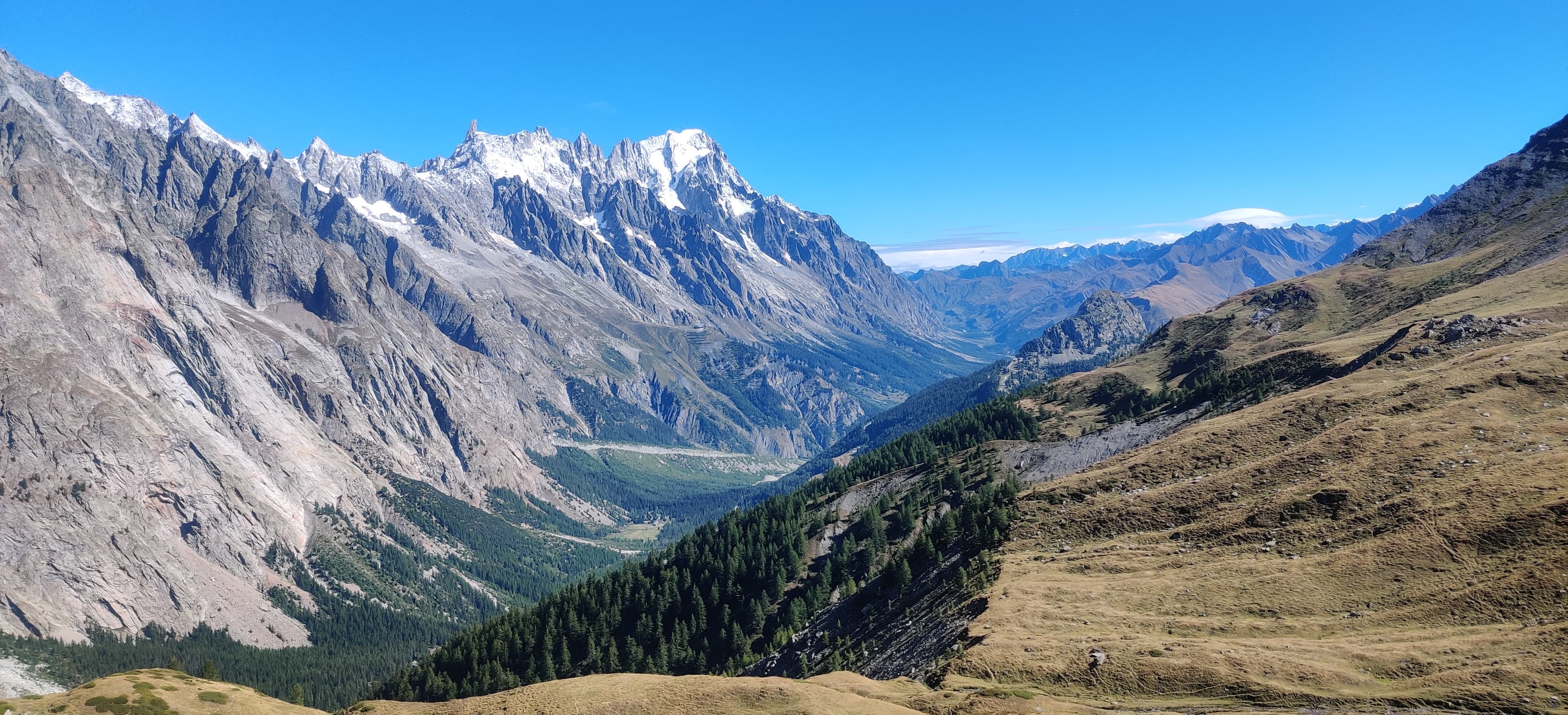
After Col de Voza, I detoured from the TMB IP (IP = Itinéraire Principal; the main route in French) and headed toward one of the detours to Col de Tricot, where I started meeting crowds of people going in the same direction as me. After that, I descended to Les Contamines, where I bought some snacks because the next shop was supposed to be 50 km away in Courmayeur, Italy. I carried food, but it’s always nice to walk into a shop and buy whatever I want, rather than being limited to whatever my backpack holds.


Full of energy after a quick stop at the supermarket in Les Contamines, I started the long climb to Col de la Croix du Bonhomme, the highest point of the TMB IP. I was still seeing plenty of hikers until the middle of the climb, where the crowds thinned out. I continued almost alone until the top, where I caught up with a young couple. I greeted them with a “bonjour,” as people usually do in the French mountains. Instead of a “bonjour” in return, I heard “ahoj.” “Did she just say ‘ahoj’ — hi in Czech?” I thought. I turned and asked, “Did you say ahoj?” — which probably sounded a bit confrontational. She looked confused for a moment, then said yes. We both laughed, realizing we hadn’t met any other Czechs that day. We chatted for a bit. While they were thinking of pitching their tent near the hut, I wanted to go a little higher to Col des Fours (2,665 m a.s.l.) before descending to the valley toward La Ville des Glaciers, where I planned to spend the night
Right after crossing the saddle, I was rewarded with a beautiful view of the mountains glowing in the setting sun. For the first time that day, I even managed to spot a glacier in the Mont Blanc massif. As I descended into the much warmer valley below, I started looking for a spot to pitch my tarp. I wanted to camp as low as possible to avoid a cold night.
Soon I reached cow fields, and after a too-close encounter with three bulls in New Zealand, I wasn’t eager to risk a repeat. I made sure not to set up anywhere cows might wander at night. Almost at the bottom of the valley, where I saw a few other tents, I passed an old abandoned barn. I checked to see if anyone was around, then tried the door. It was stuck, a good sign it wasn’t in use. Inside, it was empty — and even better, no cow droppings. Jackpot. The place was practically begging me: “Stay here tonight!” So I did.
One mouse ran across the floor, clearly checking if I had dropped food, which made me a bit nervous. I didn’t want rodents keeping me awake, so I hung all my gear on a pipe in the middle of the barn and made a deal with the mouse not to bother me. It worked! I slept well, and in the morning, I left a small piece of baguette as rent for my little French roommate.


Beware of wolfs
The night went well, and after packing up in the morning, I continued to the very bottom of the valley to a small settlement called La Ville des Glaciers, where I saw the first hikers of the day. I made a quick bathroom stop (a flushing toilet was a pleasant surprise out there) and then headed up toward Col de la Seigne. Along the way, I overtook what felt like a whole queue of TMB hikers, probably those who had camped somewhere near the valley where I had woken up.
At the top, the crowds disappeared, and for a moment I could enjoy the feeling of crossing into Italy almost alone. I snapped a few pictures, but the wind made it chilly, so I quickly descended into “bella Italia”.


I descended into the valley where I spotted an epic toilet placed right in the middle of this beautiful alpine scenery. Honestly, I almost regretted that I didn’t need to use it at that moment — a throne like that deserved more appreciation.
By now it was getting quite hot, and I still had one more climb before reaching Courmayeur — the Italian equivalent of Chamonix. Like its French cousin, it sits at the base of Mont Blanc, and the two towns are connected by a tunnel that goes straight under the massif. I was looking forward to reaching Courmayeur not only for lunch but also for a very specific mission: finding Cino, the bittersweet Italian soda I had recently talked about with friends and now couldn’t stop thinking about.
The climb before Courmayeur wasn’t too bad. 500 vertical meters that I managed to handle fairly quickly. But the descent was another story. Not because it was particularly hard, but because I was impatient. The trail was slow… or maybe I was slow. Either way, let’s just say the trail is easier to blame.
At last, I reached Courmayeur and immediately walked into the first restaurant I saw. It was a pizzeria. The pizza was huge, cheap, and delicious, ticking every single box I had at that point. With fresh energy, I was almost excited to start hiking again. But first, I had unfinished business: Mission Chinò.
I went to the supermarket, but of course, it was closed for the afternoon break. I tried other shops but it was the same story. And since I wasn’t about to hike 70 kilometers from Chamonix only to be defeated by Italian siesta culture, I waited almost an hour for the doors to open. Finally, when I walked out with a bottle of Cino in hand, I could declare Mission Chinò a success — and continue my journey around the mountain fully satisfied.


The climb out of Courmayeur to Rifugio Bertone was long-ish, but thanks to my pit stop in town, I felt great. It was still hot, but the sky was clear with no storms in sight, so I couldn’t complain. At the top, I took a short break to soak in the views of Mont Blanc and Col de la Seigne, which I had crossed just that morning. That’s one of my favorite feelings in the mountains: looking back at a place that seems impossibly far away and realizing it only took a few hours to get there on nothing but my own two feet, carrying everything I need on my back. Not everyone around me could say the same. I had just met a large guided group doing the TMB with no backpacks because they had a mule carrying everything for them. Now, the mule looked strong… but not particularly smart (sorry mule, no offense). It kept trying to wander off, only to be coaxed back by the guide waving a leafy branch like it was a carrot on a stick. Honestly though, if the mule knew how much weight it was hauling, it would probably feel way more badass than me.
After my encounter with the pack animal MVP, I continued along a beautiful single track toward Chalet Val Ferret, where I planned to camp. I hardly saw anyone, except for one biker, and otherwise I had the valley, and the dramatic Grandes Jorasses towering above all, to myself. Usually I hike in silence, but that evening I put on a podcast for company. I was listening, looking around, when I suddenly froze. Something was standing on the trail about 70 meters ahead of me. At first I wasn’t sure what I was seeing, but then it clicked: a wolf.
It stood half-hidden in the bushes, staring straight at me. I had read that wolves live in this region, but I always assumed they’d bolt the moment they saw a person. This one didn’t. I took a few careful steps forward. It didn’t move. In fact, it didn’t look scared at all. That’s when I decided not to test whether I was scarier than a wolf (spoiler: I wasn’t). My own nerves kicking in, I slowly backed away, never turning my back, until I could scramble up the slope above the trail.
The wolf calmly walked onto the path where I had been standing just minutes before, still watching me. I quickly snapped a photo with my phone, then waited, hoping the wolf would continue minding its own business. Preferably business that didn’t involve me. After a few tense minutes, it wandered off, and I cautiously made my way back to the trail. I didn’t see it again, and by sunset I reached Chalet Val Ferret. I pitched my tarp in the forest near the Dora di Ferret river, cooked a quick dinner, and crawled into bed.
What a day — pizza, Chinò, mule and wolf. Now it was finally time to go to sleep.
.")

A big thunderstorm
The next morning, I packed up my tarp and was happy to leave the spot behind. In daylight it became very clear I wasn’t the first person to camp there. The bushes decorated with toilet paper told the whole story. From there I began the climb to Grand Col Ferret, the mountain pass marking the trail’s entry into Switzerland. I overtook plenty of hikers who had stayed in the nearby hut, but by the time I reached the top, the crowds had thinned and I had the trail mostly to myself again. After snapping a few photos at the Swiss–Italian border, I started descending toward La Fouly.
No wolves this time (thankfully), but the sky made it obvious that rain was on the way. Luckily, it turned out less dramatic than it first appeared, and I managed to keep walking without much trouble. I passed through a few small villages at the bottom of the valley, and then began the climb toward Champex-Lac. To my surprise, I felt like I was flying uphill.
That’s when a random thought hit me: wasn’t the SwissPeaks 700k ultramarathon happening in this region? It’s a brutal race covering 700 kilometers with 48,000 meters of elevation gain, so I got curious and quickly checked an update from one of the runners. That lucky impulse probably saved me. Thanks to checking the update from the race I found out that the race had been temporarily paused because of a massive thunderstorm sweeping through the area. I knew to expect some rain later in the day, but I had no idea it was this serious.
Knowing this crucial piece of information, I had to rethink my plan. It was 3 p.m., and I figured I had two options: either stay put in Champex-Lac until the next day, or push a bit more to reach Col de la Forclaz and find shelter before the storm arrived.


Waiting around in Champex-Lac didn’t sound appealing, so I decided to “sprint” over the next hill, reach Col de la Forclaz, and ideally enjoy dinner at the restaurant while the storm passed. My timing was perfect! I’m still not sure if it was good planning or just the storm motivating me to move faster, but I ended up almost running some of the downhills. That would’ve been fine with fresh legs and a light running vest — but this was after nearly 120 km in three days, more than 8,000 meters of climbing, and a 10 kg backpack on my shoulders.
The important thing was: I made it. I reached the restaurant just as a massive thunderstorm rolled in, and I couldn’t have been happier to be inside, eating a burger while watching the chaos outside.
While waiting, I met a runner competing in the 400 km race of SwissPeaks. He was also stuck, waiting for the race to resume, so we had a really nice chat. By the time the storm moved on, it was about 10 p.m., and I went to pitch my tent at the small camping area next to the restaurant. I fell asleep to the sound of cowbells from a nearby herd, with the occasional flash of headlamps from runners competing in SwissPeaks making their way through the night.


Closing the loop
I woke up to the sound of gentle rain drumming on my tarp. I decided to stay in my sleeping bag a little longer and managed to pack up during a short break in the showers. Of course, as soon as I started hiking, the rain came back. Not ideal, but I only had 28 km left to close the loop, so worst-case scenario, I’d just be walking wet for part of the day.
The climb to Col de la Balme was entirely in the rain. Once I got above the clouds, it turned foggy, windy, and noticeably colder. That was all the motivation I needed to push faster and get over the pass toward La Tour. Uphill I still felt strong, but downhill my quads and knees were definitely starting to complain.
Luckily, the weather cleared by the time I reached La Tour, and I had just one final climb left. I wasn’t in a rush. The sun was out, the views were spectacular, and I had all the time I needed. Mont Blanc, Aiguille Verte, Aiguille du Midi, Grandes Jorasses… it felt like a greatest-hits album of the Alps spread out in front of me. Near La Flégère, I sat down by the path and just stared at the mountains for almost half an hour enjoying the moment.
Eventually, I began the final descent into Chamonix, where I had started less than four days earlier. My first steps in Chamonix lead to Poco Loco for a victory burger which was delicious. But the taste wasn’t so important because I was so hungry that I would probably eat even the cloth for cleanig the floor.
I’ve never liked the idea of a “bucket list”. A list of things you need to do before you die sounds too fatalistic for me. Instead, I keep a list of things I’d simply like to do in my free time. It doesn’t sound as cool, but it fits my approach better. Tour du Mont Blanc had been on that list for a few years, and now I can happily say I’ve completed it and discovered another corner of the mountains just beyond my doorstep.


Some numbers at the end
I am adding here the route I hiked and some numbers from my watch after I finished the loop.
Route: https://mapy.com/s/cabasehuce
Total distance: 162 km
Positive elevation gain: +9800 m
Number of days: 4
Total moving time: 38 hours
Fun on trails: ∞