Te Araroa Stories: Candy, Cliffs, and a Trail That Tested My Bowels
Right after leaving Queenstown, I wanted to do a quick resupply at Pack’n’Save — the mythical supermarket of low prices. It was the one and only Pack’n’Save on the South Island section of the trail, and I had to find out if all the legends were true. Spoiler: they were! I regretted that I needed only food for a few days because buying tuna and tortilla wraps for the rest of my life sounded so tempting. I managed to resist the temptation nevertheless. What I couldn’t resist, however, was buying almost half a kilo of lollies — because being an adult means no one can stop you from making terrible nutritional decisions.
With my backpack now stuffed with supplies (and probably 40% sugar), I hiked to Arrowtown, where I found a perfect spot above the town to set up my tarp. I cooked dinner and waited for Emily, who was catching the bus from Queenstown so we could meet up later. The place was perfect — great view of Arrowtown, nicely hidden, and, most importantly, flat enough to sleep without sliding downhill.
Meeting a Legend
The next morning, I set an early alarm — and by early, I mean why-is-this-even-legal early. I started hiking around 6 a.m., hoping to bump into Karel Sabbe, the Belgian ultrarunner attempting the fastest known time on the trail.
As the sun came up, the entire landscape lit up in fiery shades of orange and red. I climbed over Big Hill — one of the bigger climbs for me so far, though I’d later learn the trail had far nastier surprises in store. From the top, I could see the mountains above Macetown, carved into dramatic shapes that looked straight out of a fantasy movie.
Macetown itself is an abandoned gold-mining settlement, but walking through it felt like stepping into a Western. I half-expected a bunch of dusty gold miners to appear from behind the ruins — or maybe some bloody bandits waiting to rob them. Thankfully, I didn’t meet bandits but tons of sandflies which forced me to leave the place quickly.


After passing through Macetown, the trail continued for a few kilometers in the river. And when I say “in the river,” I literally mean in the river. Steep valley banks hemmed me in on both sides, leaving only one way forward: wading through the knee-deep stream.
And that’s when I met the legend himself — Karel Sabbe. He was heading the opposite direction, moving at a speed that can only be described as slightly supersonic. Somehow, we managed a very brief, very time-efficient conversation:
Me: “Wow, dude, you are super fast! Keep smashing the record!”
Karel: smiles
Me: “Would you mind if I take a picture with you?”
Karel: “Sure.”
Me: “Thank you! And where are you heading today?”
Karel: “Somewhere after Queenstown.” (which was still about 70 km away)
Karel: disappears into the distance 😶🌫️
Even though it wasn’t much of a conversation, I was thrilled to meet him. He finished the trail just a few days later, covering the entire 3,000 km in 31 days and 19 hours — something I can only describe as humanly insane. Having walked the trail myself, I knew that averaging almost 100 km per day over this terrain is basically an alien-level effort.
At the end of the river, I climbed to Roses Saddle and then descended to Roses Hut for a quick lunch. There, I met another cool SOBO hiker with the trail name Juicy Fruit. He was wearing sporting pineapple-covered shorts — hence the nickname. Juicy Fruit had impressive trails under his belt, including the PCT and the Jordan Trail. He casually mentioned that he had a New Zealand visa for only three months and was aiming to finish the TA in 90 days. Nothing compared to Karel Sabbe, of course, but as a “normal” self-supported hiker, that was still insanely impressive.
That day, I crossed two more hills with steep climbs and some exposed aerial sections before reaching a hut crowded with fellow SOBO hikers. The next day, I left the Motatapu Track and reached Wanaka, famous for its tree in the lake but I didn’t linger. I pushed further, logging my longest day on the trail so far: 48 km. Exhausted, I crashed at a very sketchy-looking campsite in Albert Town and didn’t care one bit.
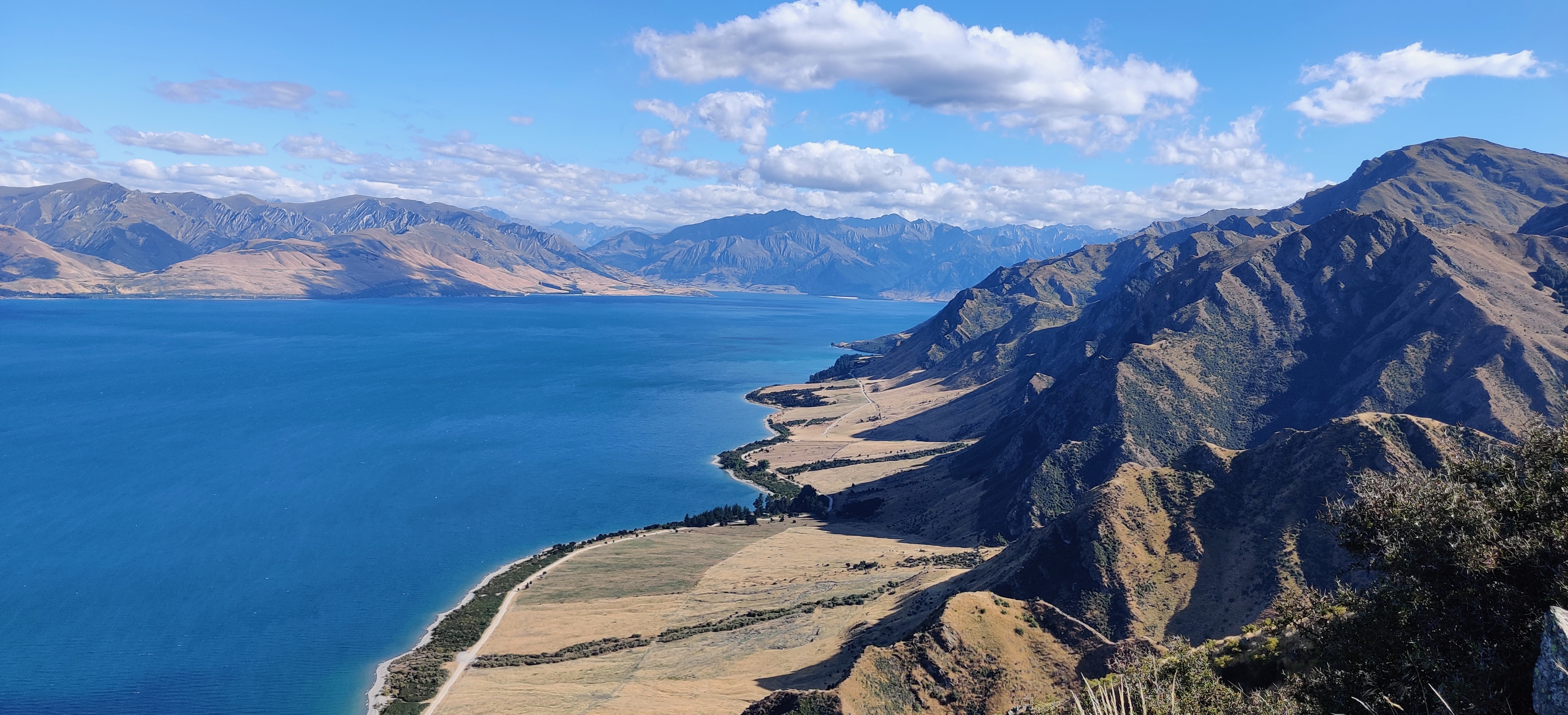
I woke up late the next day and took it easy, making my way to Lake Hawea. There, I met a group of seasoned SOBO hikers, including Rascal. She looked like a very experienced thru-hiker — and for good reason. It turned out Rascal was fairly well-known in the thru-hiking community and had been the chief of the support team that helped Tara Dower beat the Appalachian Trail FKT — the same FKT previously held by Karel Sabbe, who I’d just met a few days earlier.


The Scarriest Section on the Whole Trail
The trail from Lake Hawea climbed up Brest Hill, where I was treated to a spectacular view of the lake below. On the way up, I stopped to chat with other SOBO hikers, trying to gather as much intel as possible about the next section. I was a little worried. Some hikers were skipping this part entirely. Others described it as traumatizing or downright terrifying. Only a few said it was “alright.”
This section had very narrow paths above the river with huge vertical drops, leaving absolutely no room for error. Just two weeks before my passage, there had been a deadly accident.
There was, however, an alternate route. Instead of following the trail clinging to the cliffs, you could descend to the river and follow the riverbed for about 12 km — longer, but far less heart-stopping.
While scouting my options, I met one hiker who said the upper path was truly scary. Not long after, I ran into another SOBO with a bandaged forehead. A rock had fallen on him while he was navigating the dangerous section. That was enough for me: I decided to take the safer river route.

Even getting to the river wasn’t easy. I had to slide down a steep, sketchy slope to reach the bottom of the valley. From there, I spent about four hours mostly in the water or hopping across stones. It was surprisingly fun — and a perfect way to stay cool on a hot day.
The river itself wasn’t very deep, but a few sections came almost up to my waist. What made it trickier was the water’s grey color; even at normal water levels, you couldn’t see the bottom. I ran into one hiking couple along the way, but otherwise, I was alone with the river and my thoughts.
Following the instructions of SOBO hikers I had met earlier, I eventually deviated from the main river to follow a side stream, which later reconnect with the original trail. The trail continued to be tricky, with some scrambly sections where a single wrong step could be disastrous.
Finally, after navigating the sketchy bits, I reached Top Timaru Hut — the end of the dangerous section. I survived!


From Gut-Wrenching Disaster to Glorified Petrol Station
The small hut was full, so I had to set up my tarp outside. While eating dinner, I realized something was very wrong. I didn’t feel like eating at all — and then it hit me. Let’s just say I had an intense bout of diarrhea that night. And the fact that getting to the long-drop toilet next to the hut required walking about 200 meters and climbing two steep hills, made the whole situation even trickier. Sleep was minimal, and I decided to stay in the hut the next day to recover. I heard about a few other NOBO hikers who faced the same problem in this section and so it is likely that I drank contaminated water (even I was always using my water filter).
Despite my misery, I met some wonderful hikers who helped me out. Eline, a young Belgian hiker, spent a few hours at the hut, and we had a great deep conversation about life - a much-needed distraction for both of us. Eline had previously some rough days on the trail, so she was happy to take a little rest and talk. Then Roee from Israel appeared with extra toilet paper, which eased my worries a bit. Kodiak from the U.S. gave me a bread bun and some instant noodles perfect for an easy-to-digest meal. This was a good lesson. From then on, I always carried food that I could eat if I wasn’t feeling well. Being sick in the middle of nowhere, with the nearest civilization more than a day’s walk away over rugged terrain, is not fun. I was really grateful for these encounters and started feeling better.
Then came a surprise. About four hours after leaving, Eline returned — not smiling this time. She was limping, her shirt torn and stained with small patches of blood. I was shocked and other hikers in the hut too. She had fallen off a cliff not far from the hut and spent the next few hours trying to get back on trail. Her description was terrifying: sliding down the slope, catching a tree, then sliding again, injuring her knee in the process. This was exactly the section I had just finished, and I was silently grateful it was behind me.
After spending a day recovering in the hut, it took me three more days to reach Twizel, where I could buy food and truly relax. The first day was tough — my legs felt like empty noodles — but over the next couple of days, I regained my strength and took in some spectacular landscapes. When I finally reached Twizel, I wasn’t literally shitting my pants anymore, and I felt ready to tackle the trail again.

.")


There wasn’t much to see in Twizel — just a few shops, a school, a couple of houses, and a petrol station. One hiker I met on the trail jokingly told me that the South Island towns I’d be passing through are basically just glorified petrol stations. Twizel fit that description perfectly (I hope no one from Twizel reads this 😁)! Not much to see, but I was genuinely happy it existed. I could resupply, take a much-needed zero day, and recharge my batteries before continuing on the trail.

If you want to keep reading about my Te Araroa journey, you can continue to the next article here.